We just got back in town from a night out at Cape Tribulation, named by Captain Cook after he ran aground on the neighboring Great Barrier Reef in 1770. (In case you were wondering, he didn't sink because a piece of coral had wedged itself into the hull, slowing the leak; and he fixed the hole after an ingenious on-board engineer patched it with a sail on the outside.) The area is stunning, with crazy wild rainforest running right down to the white sand beaches.
Unfortunately, I'll have to wait to post pictures of that adventure until the next one is over. We're being picked up in 20 minutes to head out on a liveaboard dive ship for 4 nights. We're headed out with Taka dives to the far northern edge of the Great Barrier Reef: to Cod Hole, where giant cods swim around, and to Osprey Reef, to see sharks feeding. We're really excited and a little nervous!
Don't fret if you don't hear from us for a few days. We'll have a ton of stories to tell when we return on Tuesday!
XO
M&J
Thursday, September 30, 2010
Tuesday, September 28, 2010
Cairns, Qantas, The Furby
We're in Cairns, which I cannot figure out how to pronounce properly. (The Aussies say "Cannes." But they also say "baahnacle" and "putting on eehhhs." Is "Cannes" the proper pronunciation in all accents, such that I should also say "Cannes," or is it just an Australian accent saying "Cairns," such that I should not mimic -- and possibly unintentionally mock -- them by dropping the R? I have solved this so far by mumbling.) [Justin: my solution is to say it differently every other time.]
We are madly planning for the next three weeks, putting together a quick road trip to Cape Tribulation, a five-day liveabord dive trip on the Great Barrier Reef, a sailing trip to the Whitsundays, and our flights to New Zealand.
Planning makes for uninteresting blogging. So I will just inform you of this very important fact:
On Qantas (which, incidentally, is an acronym that stands for Queensland And Northern Territory Airline Service), one is prohibited from operating a Furby.

That is all.
Monday, September 27, 2010
We Survived The Australian Road Trip!
The Improbable Chariot carried us home safely to Perth!
We spent the last few days of our road trip exploring more of the tall forests in the south-western corner of the continent. From Pemberton, we zipped down to Walpole for a few nights, using that township as our base to go to the Tree Top Walk in the giant tingle forests and explore the coastline along the Indian Ocean.
The Tree Top Walk is one of Western Australia's most popular attractions. The idea is as follows. The tingle tree, the gigantic reddish Eucalyptus jacksonii, is a major eco-tourist attraction here; it grows only in a narrow strip of land in this corner of the world, and the locals say that they make you "tingle all over," and folks thus rightly come from far and wide to see them. But the tingle, despite being huge, is actually quite delicate. In order to let folks walk around them without impacting their temperamental root systems, the Department of Conservation and Land Management has built a gigantic suspended swaying walkway that is 40 meters high at its tippy-top point. The tourists pay ten bucks to walk among the tree tops of the tingles. It's really something.

40 meters is far to the ground!

The walkway feels very stable, but it is see-through.
 Cool, huh?

Justin is taller than me, so he can actually reach the tree tops.

After doing the walk, we explored the Ancient Empire, a boardwalk that allows you to walk around the tingle trees' large buttresses, again being as low-impact as possible.
Tingles are distinguished by their spreading, and often hollow, buttresses. There are a startling number of living trees growing out of totally empty, destroyed trunks.

After wandering through the base layer -- and doing the Tree Top Walk a second time -- we zipped on down to Pleasant Bay for lunch, so that Justin could dip his toe in the Indian Ocean.
We decided we had the time and inclination to take a little road trip down to Denmark, a hippie farming town that also happened to house the most beautiful, granite-lined, protected beach that either of us had ever seen.

Those are the Elephant Rocks, which supposedly look like a herd of elephants. I sort of think they look like a herd of granite, but they do make you want to swim, don't they?

The rocks provide a natural surf break. If it had been hot, we'd have jumped in for sure. As it was a bit chilly, we continued through the southwest towards Denmark, stopping off at a scenic drive or two. The scenic drives were, of course, peppered with hilariously detailed signage instructing us on which way to go for various tourist attractions.

The following morning, we scampered up Mt Frankland, a granite dome overlooking the forest, before heading on our way back to Perth.
We saw more gigantic karri trees.
We camped in a caravan park that was conveniently next door to a brewery on Lake Clifton, sampled their delicious Irish-style red ale, and cooked the last of our food before heading back to Perth today.
It has been a fantastic road trip. Campervanning is truly the only way to see the immense Western Australia; we could have spent a whole 'nother week exploring the Kimberly, up north; actually seeing more of the outback; checking out some more of the gold-mining towns; and of course spending much more time in the southwest, among those gigantic, gorgeous trees and beaches. And there has been so much I've not told you about.
There was the time we followed a whalewatching boat along Cape Naturaliste, and saw humpback whales from no more than a quarter mile.

There was the tallest Australian flagpole with the third-biggest Australian flag at a winery near Margaret River. (The owner actually got into a tiff with the Australian government about the relative sizes of their flags.)

There was the farmland among the forest.

There was the crazy red sap of the giant trees.

There was the time Justin did a little dance on a rocking bridge.

There was the Walk-Through Tree.

And all that is just from the southwest. Up north, there was so much more -- the folks we chatted with living on sheep stations, and the many emus with little emu babies, and of course the endless corrugated dusty back roads, which prompted us to write a little song about the Improbable Chariot.
[Sing to the tune of "Swimming, swimming, in a swimming pool:"]
Rental, Rental. We like to beat you up.
Before we take you back to Perth, we will clean you up.
Dirt road, dirt road, we never drove on you.
Insofar as they will know, that was always true!
(NB: we got our full deposit back on the campervan.)
Tonight we fly to Cairns to start a whole new side of this adventure. We're as excited for the next three weeks as we are grateful to have had such an excellent time these last three weeks. Hope everyone is well at home -- sayonara, Western Australia!
Meredith & Justin
 |
| My view for the past three weeks. Isn't he cute? |
The Tree Top Walk is one of Western Australia's most popular attractions. The idea is as follows. The tingle tree, the gigantic reddish Eucalyptus jacksonii, is a major eco-tourist attraction here; it grows only in a narrow strip of land in this corner of the world, and the locals say that they make you "tingle all over," and folks thus rightly come from far and wide to see them. But the tingle, despite being huge, is actually quite delicate. In order to let folks walk around them without impacting their temperamental root systems, the Department of Conservation and Land Management has built a gigantic suspended swaying walkway that is 40 meters high at its tippy-top point. The tourists pay ten bucks to walk among the tree tops of the tingles. It's really something.

40 meters is far to the ground!

The walkway feels very stable, but it is see-through.


Justin is taller than me, so he can actually reach the tree tops.

After doing the walk, we explored the Ancient Empire, a boardwalk that allows you to walk around the tingle trees' large buttresses, again being as low-impact as possible.
 |
| Don't they kind of look like ents? |

After wandering through the base layer -- and doing the Tree Top Walk a second time -- we zipped on down to Pleasant Bay for lunch, so that Justin could dip his toe in the Indian Ocean.
 |
| Literally. [Justin: Hey it was cold! There be Antarctica.] |

Those are the Elephant Rocks, which supposedly look like a herd of elephants. I sort of think they look like a herd of granite, but they do make you want to swim, don't they?

The rocks provide a natural surf break. If it had been hot, we'd have jumped in for sure. As it was a bit chilly, we continued through the southwest towards Denmark, stopping off at a scenic drive or two. The scenic drives were, of course, peppered with hilariously detailed signage instructing us on which way to go for various tourist attractions.
 |
| Pottery! Tea rooms! SENSATIONAL heights! [Justin: Another sign listed the Puzzle Shop. I was intrigued.] |

The following morning, we scampered up Mt Frankland, a granite dome overlooking the forest, before heading on our way back to Perth.
 |
| Blond hair attacks again. |
 |
| Treehugger. |
It has been a fantastic road trip. Campervanning is truly the only way to see the immense Western Australia; we could have spent a whole 'nother week exploring the Kimberly, up north; actually seeing more of the outback; checking out some more of the gold-mining towns; and of course spending much more time in the southwest, among those gigantic, gorgeous trees and beaches. And there has been so much I've not told you about.
There was the time we followed a whalewatching boat along Cape Naturaliste, and saw humpback whales from no more than a quarter mile.

There was the tallest Australian flagpole with the third-biggest Australian flag at a winery near Margaret River. (The owner actually got into a tiff with the Australian government about the relative sizes of their flags.)

There was the farmland among the forest.

There was the crazy red sap of the giant trees.

There was the time Justin did a little dance on a rocking bridge.

There was the Walk-Through Tree.

And all that is just from the southwest. Up north, there was so much more -- the folks we chatted with living on sheep stations, and the many emus with little emu babies, and of course the endless corrugated dusty back roads, which prompted us to write a little song about the Improbable Chariot.
[Sing to the tune of "Swimming, swimming, in a swimming pool:"]
Rental, Rental. We like to beat you up.
Before we take you back to Perth, we will clean you up.
Dirt road, dirt road, we never drove on you.
Insofar as they will know, that was always true!
(NB: we got our full deposit back on the campervan.)
Tonight we fly to Cairns to start a whole new side of this adventure. We're as excited for the next three weeks as we are grateful to have had such an excellent time these last three weeks. Hope everyone is well at home -- sayonara, Western Australia!
Meredith & Justin
Friday, September 24, 2010
On the Road, Version Australia: Cape Leeuwin and the Tall Forest
Hello from Walpole, Western Australia! I can't believe it, but we're coming to the end of our Western Australia road trip; we're returning our van in just two days. Fortunately we've ended our road trip with some of the best days we've had so far; the southwest of this state is truly beautiful. We could imagine getting stuck here for a while.
However, it wouldn't be Australia without some perplexing tourist attractions. If you've been reading the last couple posts, you know that Justin and I were both strangely excited to go to Cape Leeuwin, where the Southern and Indian oceans meet. Some ladies on the train from Sydney had told us that it was "really obvious" where the ocean currents crossed, and Lonely Planet had described the lighthouse marking the spot in characteristically grandiose language ("you feel like you're being blown off the edge of the earth!"), so we felt we had to go there.
We approached the lighthouse and were a little surprised to be charged $10 for entry. Skeptical, we still sprung for it; after all, we'd driven all this way. The lady at the front desk told us to stay off the rocks because there were crocodiles. No, there aren't. But we remained hopeful.
We approached the lighthouse. Justin procured it for me.

And then we wandered past the nonexistent crocodiles to the place where the oceans supposedly meet. It was helpfully designated with this sign.

But, as Justin's face indicates, we could not figure out for the life of us where the oceans met in the actual water. As we sat fecklessly scanning the horizon, looking at some rocks, an Australian couple wandered over beside us and were making the same curious, hopeful expressions at the water.
"Can you figure it out?" I asked.
"Um, hm. No," replied the Aussie bloke, gently and with a polite grin.
"Maybe it's those rocks," I said, pointing at a rock with waves crashing on it from what appeared to be opposite directions.
"Oh yeah!" the Aussies exclaimed.
We thought a minute.
"Well, maybe that's just a cross-current, actually," said the bloke.
We all sat looking at the rock some more, then decided to take victory shots in front of it just in case that was it, and went on our merry ways with appropriate goodbyes.
We wandered over to another lookout area. This one explained that Cape Leeuwin was the most south-westerly point in Australia. This is a very clever designation. It is neither the most southern, nor the most westerly point in the continent; it's just the one that's . . . most in the middle of those places.
They had telescopes set up at this display, too. Eagerly, I ducked down to see what they pointed at.

Yep. Nothing.
So we went back out to our Improbable Chariot. On the way, we passed a pirate cow.

No, I have no idea why that is there, either.
Australia is kind of like this sometimes. There are, as I mentioned, a zillion signs indicating that a tourist attraction lies just around the corner, even when the tourist attraction is a rock with a plaque on it commemorating something that no one remembers. Our guidebook, the Lonely Planet, corroborates this with complimentary language about every single place they write about. The boringest town is "an eerie memento of how life used to be during the Gold Rushes." A town that closes entirely at 8 p.m. is "sleepy and quaint, with excellent beaches." And in addition to the random inexplicable pirate cows, there are signs everywhere indicating that we should turn left to see "Another Living Window." Another living window?? Another living window? Why are you calling both a cave and a discovery center a window? We're getting used to being perplexed.
All of this faded as we drove into Tall Tree Country. We took a little detour up from Cape Leeuwin through Augusta to Nannup and across Graphite Road on our way to Pemberton, and just kept making exclamations as the trees just kept getting bigger.

We entered the karri forests with happy wondrous uplifted faces. Karri, or Eucalyptus diversicolor, is the third tallest tree in the world (California coastal redwoods, I note with pride, are the tallest). They are enormous, thin eucalypts with silver bark and startlingly straight trunks, most rising to nearly 60 meters tall. They are punctuated by jarrah and marri in the area around Pemberton, which are a bit smaller but also beautiful. The effect, as we drove into Pemberton, was lovely.
Eucalyptus is a very sheddy tree, as we Californians well know. This caused them do have to do a lot of fire management. Like everything else in Australia, fire management is a little, well, in-your-face; they just do gigantic brush burns right off the highway. We saw trees smouldering brightly at dusk on one of our drives, and Pemberton looked like this as we rolled in:
The following day we took the Karri Forest Explorer drive, meandering 86 km through three national parks on alternating dirt and bitumen, to see the area in depth. What resulted was one of our favorite days of this whole trip.

We took a LOT of pictures of trees. The photo uploader here is being slow and strange, and I can only see thumbnails, making it hard to separate the good tree photos from the boring tree photos, so I'll save the majority of them for later slideshows. But suffice to say here: these trees are BIG and COOL.

We also found ourselves hiking on sections of the Bibbulmun Track.

I'd kill to do this through-hike at some point in my life. It extends 950 km from near Perth to Albany, passing through forests and towns throughout the southwest, and at a leisurely pace it would thus take about eight weeks to do. It's named after an Aboriginal language group and commemorates the tribes' tradition of traveling long distances for ceremonies, and the sections we completed in our short tours around the area were stunningly beautiful and really well-maintained.
We also passed by several of the "climbing trees" -- old fire lookouts that have pegs in a spiral staircase around the trunk to reach the top. We opted to pop all 68 meters to the top of the Bicentennial Tree.
This was one of the most harrowing experiences of my life.

Those are just metal pegs stuck into the tree in ladder-like fashion. NOTHING BENEATH YOU. No net. The netting wires go over the sides and the top, but not below. I suppose they prevent a pop off the sides and may catch branches falling from up top, but it sure feels like you could just miss a peg and go shooting through that wide ladder. Justin and I were shaking like leaves and trying not to freeze or have heart attacks on our way up. But at 68 meters, we reached a point above all the treetops, and the view was utterly rewarding.

We're going to be on another (safer) view of those treetops today, when we do the Tree Top Walk in the Valley of the Giants near Walpole. We'll spend today and half tomorrow exploring the giant tingle forests near here, then be back in Perth returning our van on Monday.
Miss you all!
Meredith
However, it wouldn't be Australia without some perplexing tourist attractions. If you've been reading the last couple posts, you know that Justin and I were both strangely excited to go to Cape Leeuwin, where the Southern and Indian oceans meet. Some ladies on the train from Sydney had told us that it was "really obvious" where the ocean currents crossed, and Lonely Planet had described the lighthouse marking the spot in characteristically grandiose language ("you feel like you're being blown off the edge of the earth!"), so we felt we had to go there.
We approached the lighthouse and were a little surprised to be charged $10 for entry. Skeptical, we still sprung for it; after all, we'd driven all this way. The lady at the front desk told us to stay off the rocks because there were crocodiles. No, there aren't. But we remained hopeful.
We approached the lighthouse. Justin procured it for me.

And then we wandered past the nonexistent crocodiles to the place where the oceans supposedly meet. It was helpfully designated with this sign.

But, as Justin's face indicates, we could not figure out for the life of us where the oceans met in the actual water. As we sat fecklessly scanning the horizon, looking at some rocks, an Australian couple wandered over beside us and were making the same curious, hopeful expressions at the water.
"Can you figure it out?" I asked.
"Um, hm. No," replied the Aussie bloke, gently and with a polite grin.
"Maybe it's those rocks," I said, pointing at a rock with waves crashing on it from what appeared to be opposite directions.
"Oh yeah!" the Aussies exclaimed.
We thought a minute.
"Well, maybe that's just a cross-current, actually," said the bloke.
We all sat looking at the rock some more, then decided to take victory shots in front of it just in case that was it, and went on our merry ways with appropriate goodbyes.
We wandered over to another lookout area. This one explained that Cape Leeuwin was the most south-westerly point in Australia. This is a very clever designation. It is neither the most southern, nor the most westerly point in the continent; it's just the one that's . . . most in the middle of those places.
They had telescopes set up at this display, too. Eagerly, I ducked down to see what they pointed at.

Yep. Nothing.
So we went back out to our Improbable Chariot. On the way, we passed a pirate cow.

No, I have no idea why that is there, either.
Australia is kind of like this sometimes. There are, as I mentioned, a zillion signs indicating that a tourist attraction lies just around the corner, even when the tourist attraction is a rock with a plaque on it commemorating something that no one remembers. Our guidebook, the Lonely Planet, corroborates this with complimentary language about every single place they write about. The boringest town is "an eerie memento of how life used to be during the Gold Rushes." A town that closes entirely at 8 p.m. is "sleepy and quaint, with excellent beaches." And in addition to the random inexplicable pirate cows, there are signs everywhere indicating that we should turn left to see "Another Living Window." Another living window?? Another living window? Why are you calling both a cave and a discovery center a window? We're getting used to being perplexed.
All of this faded as we drove into Tall Tree Country. We took a little detour up from Cape Leeuwin through Augusta to Nannup and across Graphite Road on our way to Pemberton, and just kept making exclamations as the trees just kept getting bigger.

We entered the karri forests with happy wondrous uplifted faces. Karri, or Eucalyptus diversicolor, is the third tallest tree in the world (California coastal redwoods, I note with pride, are the tallest). They are enormous, thin eucalypts with silver bark and startlingly straight trunks, most rising to nearly 60 meters tall. They are punctuated by jarrah and marri in the area around Pemberton, which are a bit smaller but also beautiful. The effect, as we drove into Pemberton, was lovely.
Eucalyptus is a very sheddy tree, as we Californians well know. This caused them do have to do a lot of fire management. Like everything else in Australia, fire management is a little, well, in-your-face; they just do gigantic brush burns right off the highway. We saw trees smouldering brightly at dusk on one of our drives, and Pemberton looked like this as we rolled in:
 |
| FIRE! |

We took a LOT of pictures of trees. The photo uploader here is being slow and strange, and I can only see thumbnails, making it hard to separate the good tree photos from the boring tree photos, so I'll save the majority of them for later slideshows. But suffice to say here: these trees are BIG and COOL.

We also found ourselves hiking on sections of the Bibbulmun Track.

I'd kill to do this through-hike at some point in my life. It extends 950 km from near Perth to Albany, passing through forests and towns throughout the southwest, and at a leisurely pace it would thus take about eight weeks to do. It's named after an Aboriginal language group and commemorates the tribes' tradition of traveling long distances for ceremonies, and the sections we completed in our short tours around the area were stunningly beautiful and really well-maintained.
We also passed by several of the "climbing trees" -- old fire lookouts that have pegs in a spiral staircase around the trunk to reach the top. We opted to pop all 68 meters to the top of the Bicentennial Tree.
 |
| Can you see the platform midway up? Look closely. I'm on the pegs. |

Those are just metal pegs stuck into the tree in ladder-like fashion. NOTHING BENEATH YOU. No net. The netting wires go over the sides and the top, but not below. I suppose they prevent a pop off the sides and may catch branches falling from up top, but it sure feels like you could just miss a peg and go shooting through that wide ladder. Justin and I were shaking like leaves and trying not to freeze or have heart attacks on our way up. But at 68 meters, we reached a point above all the treetops, and the view was utterly rewarding.

We're going to be on another (safer) view of those treetops today, when we do the Tree Top Walk in the Valley of the Giants near Walpole. We'll spend today and half tomorrow exploring the giant tingle forests near here, then be back in Perth returning our van on Monday.
Miss you all!
Meredith
Wednesday, September 22, 2010
On the Road, Version Australia: Fremantle, Yallingup, Margaret River
Hi everyone! We're in Margaret River, one of Australia's wine-growing regions. The last four days have been so civilized!
After our last post from Perth, we drove 19 kilometers up to the mouth of the Swan River and stayed the night in the relaxed town of Fremantle, a much-beloved suburb made famous by the America's Cup, which reminded Justin a little bit of Austin. We neglected to take photos, but we really enjoyed our walk into town from the caravan park and the chili-tomato mussels and wood-fired pizza (sorry, Brandi, we eat other pizza!) that we scarfed down at Little Creatures brew pub.
The next day we got on the road down to Australia's southwest corner. The first thing I'll say is that this place is really, really pleasant. There are tall trees everywhere, shady roads, emu leather farms, black-and-white spotted cows, and all manner of tourist attractions along the side of the road. Australia's charmingly quaint boosterism is apparent everywhere; there are road signs for every possible thing that might be of interest to someone. We have actually, no joke, passed signs indicating that we should turn left in 500 meters if we wish to see things like Bella's Pottery Shack or Dwellingup's Famous Crafts or an Emu Fence. It's so darned adorable.
You know what else are adorable? PENGUINS.

We stopped in Rockingham on our way south from Freo to visit Penguin Island, an offshore sanctuary for these Little (or Fairy or Blue) penguins. They are mostly nocturnal and very hard to see, but the sanctuary has adopted ten penguins that were injured or orphaned and feeds them a couple of times a day, much to the delight of the sanctuary's visitors.

CUTE OVERLOAD. These things waddle around and eat a ton of fish and have an adorable way of communicating with their caretaker, who obviously adores them. And they are really surprisingly fast in the water.

We also took a tour to a neighboring island to see the Australian sea lions that live in the marine sanctuary. These improbable beasties -- all of whom are male, for complicated migratory reasons that I can't quite remember -- go on massive three-day feeding frenzies and then laze around like blubbery lumps for three days. We saw them in their blubber lump phase.
Behind them you see a pod of Australian pelicans, which have the longest beak of any bird in the world. (Side note: one of my favorite seaside images, which I saw ages ago in Kalbarri, was a fisherman at sunset casting his line on the beach; right at his side, keeping him company and observing his every cast, was a gigantic pelican. Two fishermen, hanging out together.)
From Rockingham, we sailed south through giant eucalyptus trees to the tiny town of Yallingup, which has a reputation for world-class surfing. The drive there had a world-class sunset, I can tell you that much.

From Yallingup, we popped down here to Margaret River, "Margs" to the locals, where we have spent the last two days. (Another tangent: have you noticed that Australians have an adorable habit of shortening everything? Fremantle is "Freo." Afternoon is "Avo." Breakfast is "Brekky." That doesn't even save a syllable.) Margaret River reminds us of Sonoma, except that everything in town closes at 8:30pm. No matter; yesterday we had our fill of tipple on a tour of six well-known wineries in the area.

I particularly liked Pierro, which has an old-school buttery chardonnay and a delicious pinot noir.
We found nothing to eat last night after our post-wine-tour nap except the Australian equivalent of Pizza Hut, but excellent lunch and someone else driving us around made for a great day.
From here, we're headed down to Cape Leeuwin to see where the Southern and Indian Oceans meet, then to the karri and jarrah and tingle trees near Walpole and Denmark. It should continue to be a pleasant and civilized journey until we return our Improbable Chariot to its Perth home on the 27th.
Cheers!
Meredith & Justin
After our last post from Perth, we drove 19 kilometers up to the mouth of the Swan River and stayed the night in the relaxed town of Fremantle, a much-beloved suburb made famous by the America's Cup, which reminded Justin a little bit of Austin. We neglected to take photos, but we really enjoyed our walk into town from the caravan park and the chili-tomato mussels and wood-fired pizza (sorry, Brandi, we eat other pizza!) that we scarfed down at Little Creatures brew pub.
The next day we got on the road down to Australia's southwest corner. The first thing I'll say is that this place is really, really pleasant. There are tall trees everywhere, shady roads, emu leather farms, black-and-white spotted cows, and all manner of tourist attractions along the side of the road. Australia's charmingly quaint boosterism is apparent everywhere; there are road signs for every possible thing that might be of interest to someone. We have actually, no joke, passed signs indicating that we should turn left in 500 meters if we wish to see things like Bella's Pottery Shack or Dwellingup's Famous Crafts or an Emu Fence. It's so darned adorable.
You know what else are adorable? PENGUINS.

We stopped in Rockingham on our way south from Freo to visit Penguin Island, an offshore sanctuary for these Little (or Fairy or Blue) penguins. They are mostly nocturnal and very hard to see, but the sanctuary has adopted ten penguins that were injured or orphaned and feeds them a couple of times a day, much to the delight of the sanctuary's visitors.

CUTE OVERLOAD. These things waddle around and eat a ton of fish and have an adorable way of communicating with their caretaker, who obviously adores them. And they are really surprisingly fast in the water.

We also took a tour to a neighboring island to see the Australian sea lions that live in the marine sanctuary. These improbable beasties -- all of whom are male, for complicated migratory reasons that I can't quite remember -- go on massive three-day feeding frenzies and then laze around like blubbery lumps for three days. We saw them in their blubber lump phase.
 |
| Lazy bums. |
From Rockingham, we sailed south through giant eucalyptus trees to the tiny town of Yallingup, which has a reputation for world-class surfing. The drive there had a world-class sunset, I can tell you that much.

From Yallingup, we popped down here to Margaret River, "Margs" to the locals, where we have spent the last two days. (Another tangent: have you noticed that Australians have an adorable habit of shortening everything? Fremantle is "Freo." Afternoon is "Avo." Breakfast is "Brekky." That doesn't even save a syllable.) Margaret River reminds us of Sonoma, except that everything in town closes at 8:30pm. No matter; yesterday we had our fill of tipple on a tour of six well-known wineries in the area.

I particularly liked Pierro, which has an old-school buttery chardonnay and a delicious pinot noir.
 |
| I am utterly sober in this photograph. |
From here, we're headed down to Cape Leeuwin to see where the Southern and Indian Oceans meet, then to the karri and jarrah and tingle trees near Walpole and Denmark. It should continue to be a pleasant and civilized journey until we return our Improbable Chariot to its Perth home on the 27th.
Cheers!
Meredith & Justin
Sunday, September 19, 2010
On the Road, Version Australia: Coral Bay back to Perth
We're safely back in the stellar public library in Perth, having completed the first leg of our journey: shown beautifully by Justin on this map. And once again, this is going to be a long post. *deep breath.* Here we go...
Day 9: Coral Bay, or, A Manta-bulous Day. Coral Bay, population 190, temporary holidayer population 1,900, is a delightful little seaside town with the world's most accessible coral reef right offshore. The beach walk we took after our last blogging episode was very shiny.

The SCUBA dive and PADI refresher course (it had been three years since my last dive, and one year since Justin's) we took the following day was world-class. Our camera isn't waterproof, so I have nothing pictoral to share with you -- but the coral bommies were gigantic, and we saw little yellow box fish, an octopus, a nurse shark named Matilda in a cave (who came out to say hello, chomping her teeth ominously), and a huge 4-meter-wide manta ray doing barrel rolls to feed, which looks like this.
Coral Bay also gave us our first taste of kangaroo. Aussies are obsessed with barbecues, and almost every caravan park we have stayed in has had one available. [Justin: Really, though, they are griddles! What's so hard about a normal grill?] We picked up some 'roo kabobs, whipped 'em up on the grill, and ate them in the van. They were delicious, see?

Day 9: Coral Bay to Exmouth to Giralia Bay, or, Darn You, Exmouth! It has to happen at least once every trip. You have a day where nothing goes particularly right. The snorkel gear you rent is broken (twice), the campsites in the national park you want to visit are all booked, by the time you've paid for your snorkel gear the weather is threatening a monsoon, the guy at the health food store thinks you said "latte" instead of "lassi," so you get a hot caffienated drink instead of a cold fruity one, etc. And you don't get to eat any of the town's famous king prawns. That was our day through Exmouth. So this was the only photo we took on the Exmouth / Cape Range National Park peninsula.
We fled the cursed town and stayed the night on a homestead called Giralia Bay. Which, incidentally, is not really near any water, but still has this charming sign.
Day 10, 11, and 12: Karijini National Park, or, This Place is Gorges! From Giralia Bay we hightailed it to Tom Price, going stir-crazy in the car. I know I said it before, but I've got to say it again: Australia is FRIGGIN EMPTY. Justin and I were crazily singing songs about emus and dugongs and taking photos out the window of piles of rocks. You think I'm kidding?

Yes. Those are rocks. That we were excited to photograph. At one point we got out of the car to take pictures of ourselves among rocks. Australia does this to a person. And this to our gas tank.

We made it on fumes to Tom Price, a nice little town full of miners and their wives and babies. We took a "spinifex walk" to Mount Nameless from our caravan park, picked up a cord for our iPods so we didn't have to listen to each other's songs about emus and dugongs anymore, and prepared for the following day in Karijini National Park.
Karijini is Western Australia's second-largest national parks and one of its most popular, despite being quite far from anything. Its signature attractions are its river gorges. Like most national parks in Australia, its offerings for visitors are a little bit limited; there were only a couple kilometers of walks through the park. But what kilometers they were.
We spent our first day exploring Dales Gorge, a stunning walk past waterfalls, swimming holes, ferns, and gigantic red walls. We swam at Fortescue Falls,
... and saw a goanna,

... and then went to the park's signature lookout over four different gorges.

After staying the night in an "eco lodge" in the park, we explored way down in those gorges (Weano and Hancock) in the morning. I don't mean to scare you, Mom, but it was a wee mite bit sketchy. The red rocks were worn glass-smooth from many years of erosion and flash floods and people walking on them, and the trail spent a long time being underwater. We swam. A lot.
Those safety-conscious Aussies thought to put a handrail in only once: when the trail went thirty feet of vertical down a waterfall.

Every other time, they just put a little trail marker saying "go this way." Sometimes "this way" looked a little bizarre.
But it was beautiful. Really beautiful. And really fun. And Justin only fell once! [Justin: but not on the hard part!]
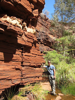
Before I move on, I have to share with you some final observations about Karijini. First, as you can tell from these photos, the land is red. It's very, very striking, and the photos don't capture the depth of the color on the gorge walls, or just in the land itself, particularly when the shadows get long.

Second, the main road through Karijini is, as you can see from the above shot, unsealed. Western Australia is so empty that most of the roads outside the main huge highways are not paved. This makes them bouncy and corrogated for many, many, many kilometers. Justin liked driving through puddles in an effort to make our van respectably dirty, and I dare say he succeeded. I just tried to keep the fillings in my teeth in place. These roads are so rugged that the 70+ kilometers we drove through Karijini actually churned the cream we have in our van's fridge into butter. (I couldn't make that up. It happened.)
Day 14: Newman to Payne's Find, or, The Long Drive. We woke up in Newman (where I poured butter into my morning coffee) prepared to make the long haul down the middle of the country, in the outback, as efficiently as we safely could. And we did: we drove nearly 700km yesterday down the middle of Western Australia, with 53-meter road trains (basically three trucks hitched together) flying past us. Some of them were extra wide. Some of the extra wide trucks were extra extra wide. We had to pull over for this one:
9 hours in the car with an aching back prompts me to crack stupid jokes.
JUSTIN: "Hm. We're passing a place called Youthapina. I wonder what that is."
MEREDITH: "If Youthapina me, then I'll testify."
JUSTIN: "......."
It also prompts me to do the happy dance when exiting the vehicle, no matter how utterly crappy the caravan park is.
Note to all future travelers: skip Payne's Find. Its tourist attraction was a Gold Battery, which was closed, and alongside a large pile of rusty things without any explanation whatsoever.
And its "pub" was like walking into someone else's living room. We ate rice and beans in the campervan and pushed on the following morning back to Perth.
Day 15: Payne's Find to Perth, where we are now, and probably to Fremantle. We stopped for lunch at Australia's only monastic town, New Norcia, which is run by benedictine monks. They fry up a mean steak sandwich and brew up a delicious Abbey Ale.

It was a really improbable place. Very peaceful. Big gum trees, a healthy bread-baking business, lots of large old monk-y looking buildings and cathedrals. We purchased a loaf of olive bread and a bottle of monk-made muscat and are back in civilization now, having successfully navigated the suburbs of Perth. It feels like we came from the outback two seconds ago, and these rolling hills and large eucalypts are surprising.
We're going to explore Fremantle, Perth's port cousin, tonight, and then make a loop through the southern corner of Western Australia in the van over the next week. We're expecting a great contrast to the huge, long, empty distances through the outback that we have just covered. We're particularly excited for Margaret Valley's wines; seeing Point Leeuwin, where the Indian Ocean meets the Antarctic; and exploring the gigantic old-growth tingle forests near Walpole.
Oh. And we've been traveling together now for a month. And yes: we still really like each other.

We should have better Internet access as we explore the south, so hopefully I'll be able to blog more than once a week. A big hug to our families and friends: we miss you guys like crazy.
xoxo,
Meredith [and Justin]
Day 9: Coral Bay, or, A Manta-bulous Day. Coral Bay, population 190, temporary holidayer population 1,900, is a delightful little seaside town with the world's most accessible coral reef right offshore. The beach walk we took after our last blogging episode was very shiny.

The SCUBA dive and PADI refresher course (it had been three years since my last dive, and one year since Justin's) we took the following day was world-class. Our camera isn't waterproof, so I have nothing pictoral to share with you -- but the coral bommies were gigantic, and we saw little yellow box fish, an octopus, a nurse shark named Matilda in a cave (who came out to say hello, chomping her teeth ominously), and a huge 4-meter-wide manta ray doing barrel rolls to feed, which looks like this.
Coral Bay also gave us our first taste of kangaroo. Aussies are obsessed with barbecues, and almost every caravan park we have stayed in has had one available. [Justin: Really, though, they are griddles! What's so hard about a normal grill?] We picked up some 'roo kabobs, whipped 'em up on the grill, and ate them in the van. They were delicious, see?

Day 9: Coral Bay to Exmouth to Giralia Bay, or, Darn You, Exmouth! It has to happen at least once every trip. You have a day where nothing goes particularly right. The snorkel gear you rent is broken (twice), the campsites in the national park you want to visit are all booked, by the time you've paid for your snorkel gear the weather is threatening a monsoon, the guy at the health food store thinks you said "latte" instead of "lassi," so you get a hot caffienated drink instead of a cold fruity one, etc. And you don't get to eat any of the town's famous king prawns. That was our day through Exmouth. So this was the only photo we took on the Exmouth / Cape Range National Park peninsula.
 |
| Darn you Exmouth! Darn you and your giant prawns! |
 |
| Wishful thinking? |

Yes. Those are rocks. That we were excited to photograph. At one point we got out of the car to take pictures of ourselves among rocks. Australia does this to a person. And this to our gas tank.

We made it on fumes to Tom Price, a nice little town full of miners and their wives and babies. We took a "spinifex walk" to Mount Nameless from our caravan park, picked up a cord for our iPods so we didn't have to listen to each other's songs about emus and dugongs anymore, and prepared for the following day in Karijini National Park.
Karijini is Western Australia's second-largest national parks and one of its most popular, despite being quite far from anything. Its signature attractions are its river gorges. Like most national parks in Australia, its offerings for visitors are a little bit limited; there were only a couple kilometers of walks through the park. But what kilometers they were.

We spent our first day exploring Dales Gorge, a stunning walk past waterfalls, swimming holes, ferns, and gigantic red walls. We swam at Fortescue Falls,
 |
| That's Justin's splash! |

... and then went to the park's signature lookout over four different gorges.

After staying the night in an "eco lodge" in the park, we explored way down in those gorges (Weano and Hancock) in the morning. I don't mean to scare you, Mom, but it was a wee mite bit sketchy. The red rocks were worn glass-smooth from many years of erosion and flash floods and people walking on them, and the trail spent a long time being underwater. We swam. A lot.
 |
| I'm not wearing pants for a reason. |

Every other time, they just put a little trail marker saying "go this way." Sometimes "this way" looked a little bizarre.
 |
| That's the trail. In the water. Which came up to my chin. |
 |
| That's the trail. Down a raging water chute. One is supposed to stem along with one's feet and hands on opposite walls. They call this the "Spider Walk." I call it a tort waiting to happen and declined to proceed. |
 |
| We survived the gorges! |

Second, the main road through Karijini is, as you can see from the above shot, unsealed. Western Australia is so empty that most of the roads outside the main huge highways are not paved. This makes them bouncy and corrogated for many, many, many kilometers. Justin liked driving through puddles in an effort to make our van respectably dirty, and I dare say he succeeded. I just tried to keep the fillings in my teeth in place. These roads are so rugged that the 70+ kilometers we drove through Karijini actually churned the cream we have in our van's fridge into butter. (I couldn't make that up. It happened.)
Day 14: Newman to Payne's Find, or, The Long Drive. We woke up in Newman (where I poured butter into my morning coffee) prepared to make the long haul down the middle of the country, in the outback, as efficiently as we safely could. And we did: we drove nearly 700km yesterday down the middle of Western Australia, with 53-meter road trains (basically three trucks hitched together) flying past us. Some of them were extra wide. Some of the extra wide trucks were extra extra wide. We had to pull over for this one:
 |
| IT WAS IN OUR LANE. |
JUSTIN: "Hm. We're passing a place called Youthapina. I wonder what that is."
MEREDITH: "If Youthapina me, then I'll testify."
JUSTIN: "......."
It also prompts me to do the happy dance when exiting the vehicle, no matter how utterly crappy the caravan park is.
 |
| Also notice the healthy amount of red dirt on our van. |
 |
| No clue. |
Day 15: Payne's Find to Perth, where we are now, and probably to Fremantle. We stopped for lunch at Australia's only monastic town, New Norcia, which is run by benedictine monks. They fry up a mean steak sandwich and brew up a delicious Abbey Ale.

It was a really improbable place. Very peaceful. Big gum trees, a healthy bread-baking business, lots of large old monk-y looking buildings and cathedrals. We purchased a loaf of olive bread and a bottle of monk-made muscat and are back in civilization now, having successfully navigated the suburbs of Perth. It feels like we came from the outback two seconds ago, and these rolling hills and large eucalypts are surprising.
We're going to explore Fremantle, Perth's port cousin, tonight, and then make a loop through the southern corner of Western Australia in the van over the next week. We're expecting a great contrast to the huge, long, empty distances through the outback that we have just covered. We're particularly excited for Margaret Valley's wines; seeing Point Leeuwin, where the Indian Ocean meets the Antarctic; and exploring the gigantic old-growth tingle forests near Walpole.
Oh. And we've been traveling together now for a month. And yes: we still really like each other.

We should have better Internet access as we explore the south, so hopefully I'll be able to blog more than once a week. A big hug to our families and friends: we miss you guys like crazy.
xoxo,
Meredith [and Justin]
Subscribe to:
Posts (Atom)